
Sheboygan River Water Trail
CLIENT
Sheboygan County Planning and Conservation
LOCATION
Sheboygan County
STATUS
Completed
ESTABLISHED
January 2019
SIZE
n/a
CATEGORY
Park / River / Trail
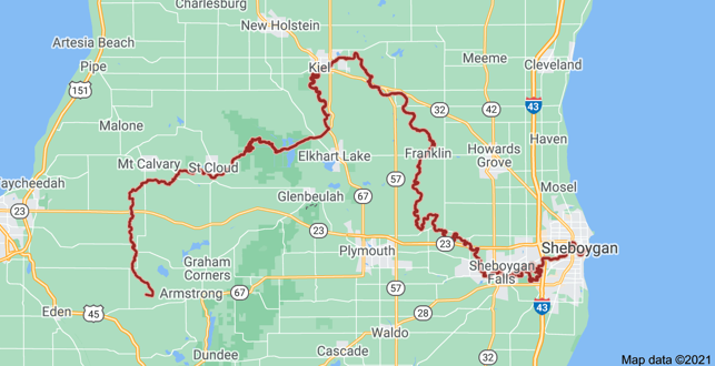
Click Map for the Sheboygan River Water Trail Interactive Online Map

The Sheboygan River Water Trail Interactive Online Map was launched in 2019 to help plan safe trips along the Sheboygan River. Use this map to find canoe and kayak access points, calculate distances, pinpoint your location, and identify other points of interest and public areas along the river.
The Sheboygan River Water Trail is designed to improve access and encourage recreational use and thereby build appreciation, understanding, and stewardship of the Sheboygan River. This project is being developed in collaboration with Lakeshore Natural Resource Partnership, the Sheboygan County Planning and Conservation Department and YMCA Camp Y-Koda, with funding from private foundation and state grants.
Planning a Safe Paddle
Although the Sheboygan River Water Trail is not as “wild” or isolated as many popular water trail routes, the power and unpredictability of our rivers should never be underestimated!
It is important to plan properly before any river excursion to ensure that a safe and fun time is had by all. Before setting out, acquaint yourself with your desired route using the Route Description on the Sheboygan River Water Trail map. Choose a distance and degree of difficulty that is most comfortable for you. (Keep in mind most people paddle two to three river miles per hour, and that water levels can speed up or slow down your trip). When paddling in downtown Sheboygan, please stay to the sides of the river, beware of motorized boat traffic, and wear your PFD.
It is advisable to always travel with: a companion or group, multiple maps, a whistle or other sound producing device and to advise someone of your plans before you go. Before you go make sure you check: water levels, potential hazards, and required/recommended portages.
In case of emergency, dial 911 and contact the U.S. Coast Guard at (920) 452-0346 or on channel 16 of your marine VHF radio.
Water levels and hazards: Water levels and flow can vary greatly with rainfall, affecting safety both on the land and in the water. Children should be warned to stay away from the rivers during times of high and fast water (usually during spring flood events). Higher water, while making some shallow rivers more accessible, generally increases level of difficulty due to increased hazards such as low bridges, snags, concealed boulders, and low hanging trees.
Paddling in high water should be exercised with extreme caution. Real-time water levels of our local rivers can be found on the USGS website.
Natural features of the stream bed such as rocky boulder beds, mud, sand, and gravel vary throughout the length of the rivers, and can be difficult and challenging to beginning boaters. There are a few required portages to note: around Bridge Street Dam in Grafton; around Thiensville Dam; around the natural falls in Kletzsch Park; and around the Estabrook Falls (downstream of the former dam). There is an optional portage bypassing the North Avenue rapids upstream of the former dam/pedestrian bridge (recommended during very high or very low water).
To report hazards or obstructions on the rivers, please, call Milwaukee Riverkeeper at (414) 287-0207.
General safety tips:
Always wear a U.S. Coast Guard approved Personal Flotation Device (PFD)—a PFD is legally required for each person on board and can save your life!
Don’t be left up the creek without a paddle—always bring an extra one along.
Consider seeking formal boating instruction, attending a boating safety class, and/or practicing paddling/rescue skills before your trip.
Dress appropriately for the weather and anticipate weather changes, especially when paddling in cold water (use of dry suit or wet suit recommended); it is always a good idea to bring extra dry clothes with you and keep them stored in a waterproof bag.
Wear brightly colored clothing, especially if in a low-riding boat such as a sea kayak (kayaks are not easily seen by motorized boaters, especially when gray or blue in color).
Remember to review your exit points and portages before embarking on your trip, and be aware of any hazards.
When paddling along the Milwaukee Estuary, inner harbor, Port of Milwaukee, and Milwaukee Mooring Basin, exercise extreme caution and stay in marked channels to ensure your safety and to minimize conflicts with motorized boats, barges, and ships. Milwaukee has an operating port, and paddling in the Port area and Municipal mooring basin is a potential hazard.
Make sure you bring adequate drinking water and more than enough provisions for your trip.
Extra safety equipment may include: a first aid kit, insect repellent, sunscreen, rain gear, extra lashing line, and dry bags or storage containers.
Do not paddle under the influence. Breweries should be a “take-out” and not “put-in” access point!
If paddling at night, you are required to have one white light to improve visibility to other boater traffic.
For more safety information, please check out the following websites:
For information on local weather conditions, please check out the following websites
Canoe Rentals and Trip Providers
Milwaukee Kayak Company For information on reservations email info@milwaukeekayak.com or call (414) 301-2240.
In case of emergency, dial 911 and contact the U.S. Coast Guard at (920) 452-0346 or on channel 16 of your marine VHF radio.
Interactive Online Map
A full version of the map above may be found on Sheboygan County’s ArchGIS website found here.